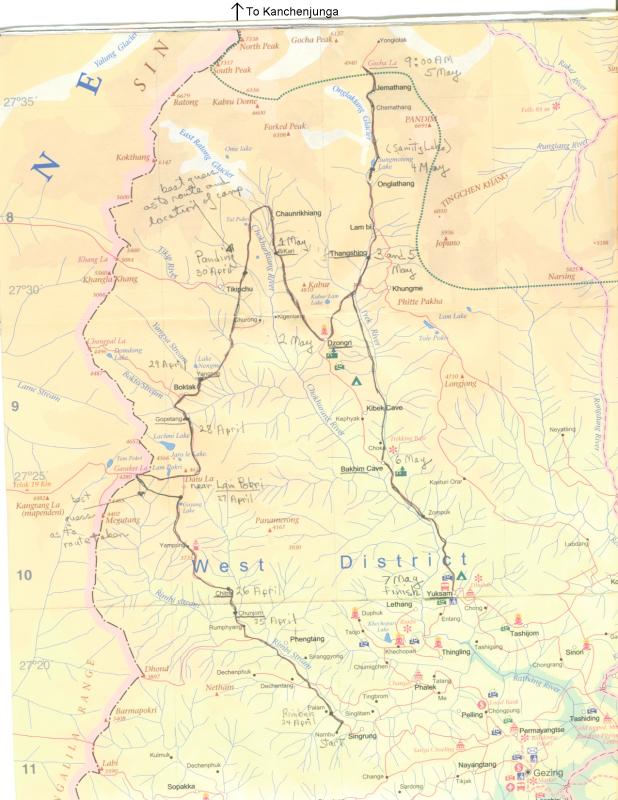
The Trek Route
The trek really began with a few days in Darjeeling,
a hill station during the time of the British raj, but now a city of
100,000 people and a weekend retreat for middle-class Calcuttans.
From there we travelled to Pelling by bus (it's on the map in the
lower right-hand corner), and then on to Nambu, the next day.
The original plan was to trek along the Singalila ridge separating
Nepal from Sikkim (India), but snow along parts of the ridge was
reported to be too deep for the dzos (a cow-yak crossbreed used to
transport gear and supplies), so we trekked up an adjacent valley.
This was disappointing, since there are supposed to be wonderful views into
Nepal (Everest in the distance) and of Kanchenjunga, and I, and many
others on the trek, chose this particular trek because of the planned
ridge walk. We did actually cross the Singalila ridge at Garaket La
[4,280m/14,042ft] ("la" means pass in the local language) and stepped
briefly into Nepal.
We did get some early morning views of Kanchenjunga from Dzongri Hill,
overlooking our camp at Dzongri, and later that day from along the trail
to our next camp at Thangshing.
The highest point reached was the Gocha La at 4,940m/16,207ft, where we
turned around, descending to Yuksam, where the paved road ends. From
there we went by bus to Kalimpong, another hill station, and then on
to Delhi and home.
Click
 Return to Thumbnails |
 Next Image |